Master Esri EADP19-001 Exam with Reliable Practice Questions
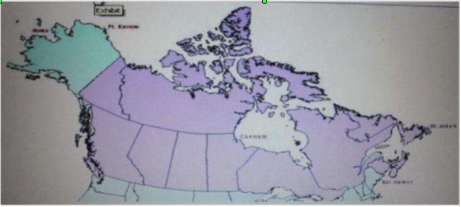
Refer to the exhibit.

The ArcGIS user is given data for the Arctic, and is asked to perform various types of analysis using the dat
a. The data extends from the North Pole south to 55 degrees North Latitude Data layers may contain points lines, or polygons and include ice surveys from NOAA depth contours; continental margins, locations of known and suspected oil reserves, endangered species habitat and territorial boundaries for nations having Arctic coastline.
An ArcGIS user is asked to calculate the distance a cruise ship will travel through open water, departing from Nome, Alaska, with stops at Point Barrow Alaska Churchill Manitoba St John's Newfoundland and ending in Bar Harbor Maine. On the basis of these calculations the cruise ship line will determine fuel requirements and travel time.
Which map projection yields the most accurate results for this distance calculation?
Correct : B
Start a Discussions
An ArcGIS user is tasked with creating a map of the state of Utah displaying all the rivers for a conservation group. The conservation group is only interested in seeing rivers longer than 15 miles, where the longer rivers appear thicker using graduated symbols.
What are two ways the ArcGIS user can eliminate rivers less than 5 miles in length from appearing in the map? (Choose two)
Correct : B, D
Start a Discussions
An ArcGlS administrator is creating a custom toolbar containing tools commonly used throughout the administrator's organization. The tools include browsing, querying, and editing tools. All tools will be located on a single custom toolbar.
How can this custom toolbar be designed to maximize efficiency?
Correct : A
Start a Discussions
The ArcGIS user is given data for the Arctic and is asked to perform various types of analysis using the dat
a. The data extends from the North Pole south to 70 degrees North Latitude Data layers may contain points lines, or polygons, and include ice surveys from NOAA depth contours: continental margins, locations of known and suspected oil reserves, endangered species habitat, and territorial boundaries for nations having Arctic coastline.
Which map projection should be used for the data to allow the most accurate buffering of those areas, in order to comply with the U.S court decision that ships may not approach closer than 20 nautical miles to a seal rookery?
Correct : C
Start a Discussions
An ArcGiS user is working with a composite address locator that consists of the following:
* Citywide Address Locator
* Regional Address Locator
* Nationwide Address Locator
How does a composite address locator work if no selection criteria are specified? (Choose two)
Correct : B, D
Start a Discussions